Maidenhead
experiences worst flooding in 10 years
November 2000(See also the extra
photos)
|
![Flood Warning](floods2000/DCP00513_small.jpg) |
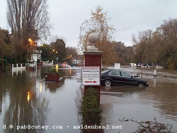
The River Thames
overflowed its banks in Maidenhead on Tuesday (7 November
2000). This was due to the huge amount of rain falling in
the area upstream in the last week or so. That night the
river was lapping up over the pavement along some parts
of Ray Mead Road (the road towards Cookham). The river
was in a Flood Warning state at the time.
The flooding worsened overnight and
the road was closed by police as it was impassable by
Wednesday morning. The river status was upgraded to Severe
Flood Warning.
Update - Thursday 9 November
23:00 - Ray Mill Road is still closed between the
bridge and Boulters Lock. The waters are thought to
have peaked now, and stayed fairly constant overnight
at just below the level of the 1990 flooding. There
is also some flooding around roads near Cookham
bridge, and in Bray. River state in the Maidenhead
area is still Severe Flood Warning. (Update
ends)
Update - Friday 10 November
08:30 - The road is still closed, however the
Environment Agency have downgraded the river status
to Flood Warning. The waters are expected to
drop slowly. (Update ends)
Update - Friday 10 November 23:00 - The
road is still closed, and the flooding is slowly dropping. (Update
ends)
Update - Sunday 12 November 23:00 -
The road is now open. The flooding is now slowly dropping. The road
and pavement is clear of river water, though the Thames is still
much higher than normal. (Update ends)
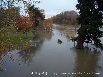
The Flood Alleviation scheme
covering Maidenhead, Windsor and Eton is due to be
completed in 2001. It was started in 1996. Unfortunately
it was not able to help during this flood because
although a number of channels have been excavated they
are not yet linked.
These photographs were taken on
Thursday morning, 9 November, unless otherwise stated.
![](floods2000/DCP00510_med.jpg) |
<<
Along Ray Mill Road. The road is on the left, the
river to the right beyond the car park and
stranded car. |
![](floods2000/DCP00500_med.jpg) |
<<
The grass area near the bridge, with flooded
seat. The water is about 10 metres from the river
edge here. |
![](floods2000/DCP00497_med.jpg) |
<<
Looking from the bridge over towards the rowing club. |
![](floods2000/DCP00499_med.jpg) |
<<
The grass area near the bridge.Compare this to the same view in
normal conditions, below.
|
Below:
Roughly the same view as above, in normal conditions,
taken during the summer months.
![](../tour/river.jpg)
More photos >>>
|